Data sources
The data used in this platform comes from the high-resolution climate model CCAM (Conformal Cubic Atmospheric Model) developed by the Commonwealth Scientific and Industrial Research Organisation (CSIRO) of Australia. CCAM is capable of simulating climate and weather with great precision, reaching resolutions of up to 200 meters. It uses a variable-resolution grid, meaning it models the climate globally with high precision in the area of interest, while using a lower resolution in other parts of the world.
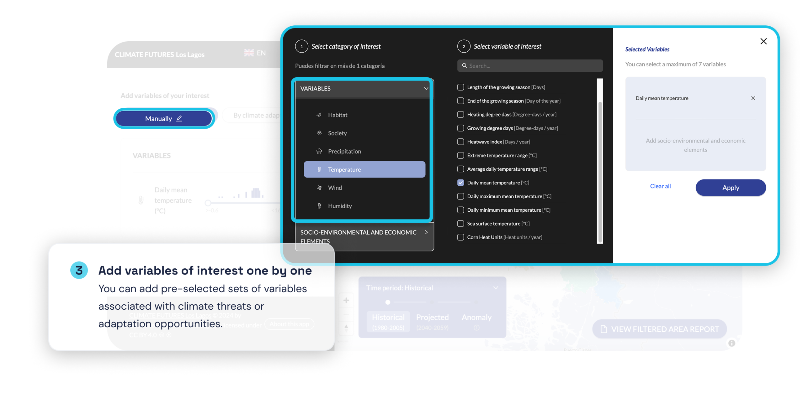
The platform also incorporates a variety of territorial information in categories such as infrastructure (road, energy, sanitation, among others), protected areas, and census data (population and housing). This data is undoubtedly a small sample of the large amount of data potentially needed to analyze the countless interactions between the future climate and the ecological and socio-productive systems of the region. We invite you to write to us with suggestions for other data of interest to be loaded into the platform, and suggestions for its improvement.
The button below provides access to the metadata for all geographic information available on this portal.
Access conditions
La plataforma es de uso gratuito y cualquier persona u organización puede hacer uso de ella.
The platform is free to use and any person or organization can make use of it.
If more in-depth support is required, specialized services, technical consulting, customized analyses, and training programs for teams can be contracted.
What this aplication does not do
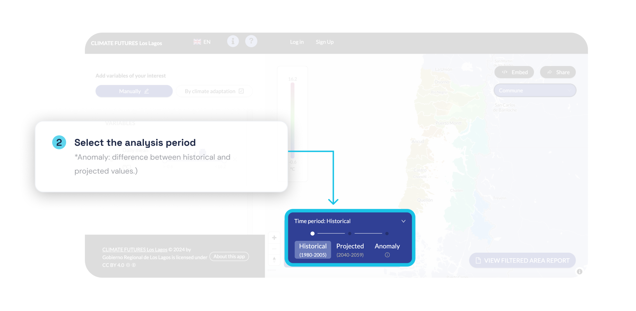
This web application provides tools to analyze possible impacts associated with climate futures based on climate models and projections. However, it is important to note that this application does not aim to predict the weather for the coming hours or days, nor to provide forecasts at scales smaller than 5 kilometers. Rather, it focuses on the projection of long-term climate patterns (decades and beyond) and their interaction with the ecological and socio-productive systems of the region.
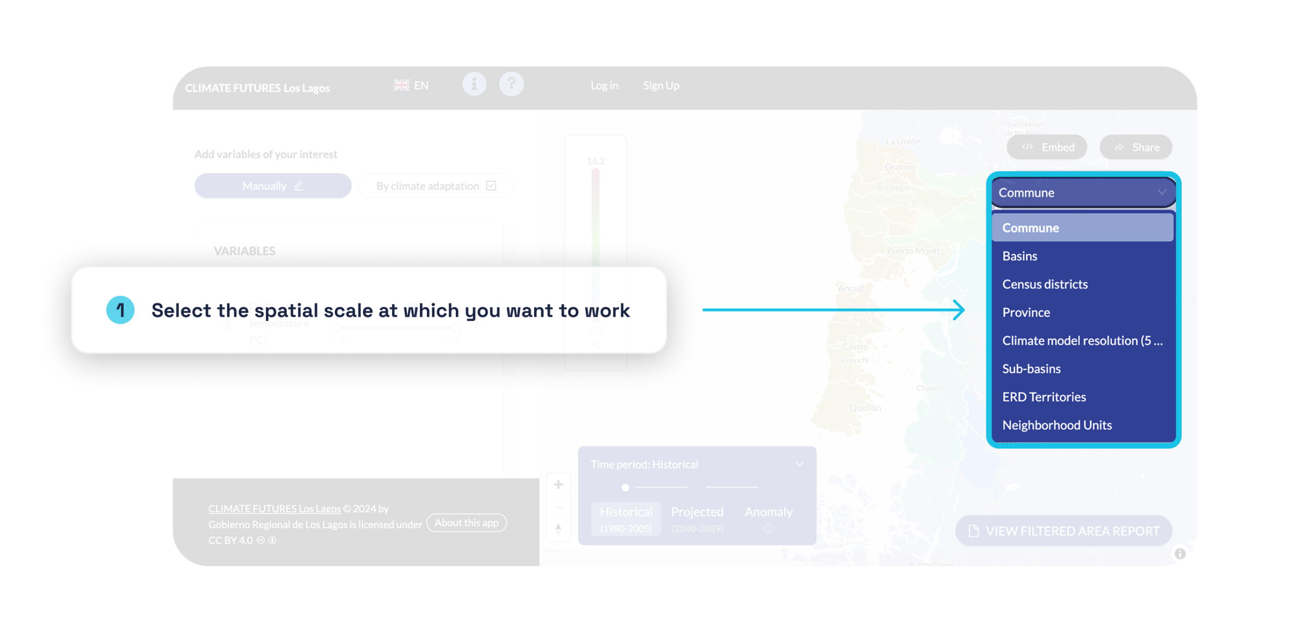
It is suggested to use this application preferably at regional planning scales or as support for municipal and regional climate adaptation initiatives and action plans. Its use is less suitable at urban planning scales or below 5 km².
It is important to note that climate risk assessment does not depend solely on quantitative data, as while some risk components have widely available data, other elements require the incorporation of proxy indicators or expert assessments.
The data and results presented in this application are subject to uncertainty inherent in predictive models and the natural variability of the climate. Therefore, users should understand that the results obtained here are scenario-based estimates and represent the best estimate of the region's future climate.
It is the user's responsibility to interpret and use the results of this application appropriately and with a full understanding of its limitations. It is not recommended to make critical decisions based solely on the information provided by this application without consulting additional sources or subject-matter experts.
Project team
This tool was developed by a multidisciplinary research team, together with specialists in territorial planning and web developers, with the support of the Regional Government of Los Lagos and the Division of Regional Planning and Development (DIPLADE) through project BIP 40047173-0 "Science-based tools to support territorial planning in the Los Lagos Region," executed by CSIRO Chile Research.
We invite you to contact us with questions, concerns, interest in collaborating, or any comments you wish to share. Your feedback is invaluable to us and helps us continuously improve. You can reach our team by email at contacto@futurosterritoriales.cl.
Research Team – CSIRO Chile Research
- Francisco Bravo — Project Coordinator, Researcher
- Álvaro Salazar— Researcher
- Claudio Pareja— Researcher
- Maria Paz Acuña— Researcher
- Diego Ocampo— Researcher
- Jonathan Hodge— Geodata Analysis and Visualization Support
- Benjamín Santana— Research Intern
Technical Counterpart – Regional Government of Los Lagos
- María Ester Sepúlveda Briceño
- Claudia Renedo Skarneo
- Andrea Orrego Tobar
- Karen Montesinos Pulgar
- Andrea Rocha Palavecinos
- Noemí Parcet Arriagada
- Carolina González Cabezas
- Pablo Soto Salazar
- Ivar León León
- Rocío Vera Garay
- Jorge Medel Águila
- Santiago Troncoso González
- Jorge Vera Ruíz
- Óscar Oyarzo Pérez
Web Application Development Team – Indaga Consultores
- Tomás Valdivieso
- Eduardo Peña
- Amanda Torres
 English